



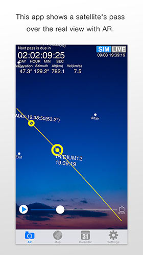
Most intuitive satellite tracker to sight International Space Station(ISS), SpaceX Starlink and others using AR, augmented reality technology.

App Overview

SpaceStationAR is an app that uses augmented reality (AR) to intuitively simulate how satellites appear in the sky. You can search for the International Space Station, Starlink trains, the Chinese Space Station, and other bright satellites by overlaying them on the real scenery around you.

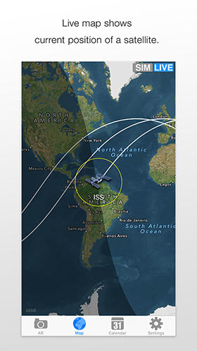
Point your iPhone or iPad camera at the landscape to check the direction and path of a satellite on the spot. In addition to satellites, the app can also display bright stars, galaxies, black holes, planetary probes, and cities beyond the horizon. You can also review satellite motion and orbits on maps and, in the Pro edition, celestial charts.

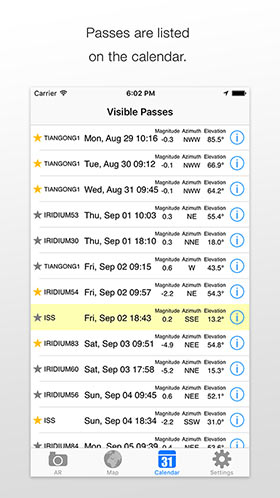
The Calendar tab lists upcoming satellite passes and rocket launches within the next two weeks, so you can pick an event and jump straight into the AR simulation. On iOS, Apple Watch and the Today widget are also supported, making it easy to check forecasts without opening the main app.

Main Features

More to read:
How to watch satellites
Visible satellites overview (Japanese)

アプリ概要

SpaceStationARは、人工衛星の見え方をAR (拡張現実) で直感的にシミュレーションするアプリです。夜空に輝く国際宇宙ステーションやスターリンクトレイン、中国宇宙ステーションなどを、実際の風景に重ねて探すことができます。

iPhoneやiPadのカメラを風景にかざすと、衛星の通過方向や軌跡をその場で確認できます。人工衛星だけでなく、明るい恒星・銀河・ブラックホール・惑星探査機・地面の向こう側の都市なども表示でき、地図や天球図 (天球図はPRO版のみ) でも衛星の軌道を確認できます。

「カレンダー」画面では、2週間以内の人工衛星通過やロケット打ち上げ情報を一覧表示。気になる通過を選んで、すぐにARシミュレーションを見ることができます。iOS版は、Apple Watchアプリや "Today" ウィジェットにも対応しており、アプリを開かなくても予報をチェックできます。

主な機能

読みもの:
人工衛星の見つけ方
肉眼で見えるかもしれない人工衛星たち

FAQ

What does SpaceStationAR do?
SpaceStationAR is an intuitive satellite-observation app that uses augmented reality. It predicts when and where satellites will appear and overlays that information on the real scenery.
Which satellites does it support?
This app focuses on satellites and spacecraft that have a realistic chance of being seen with the naked eye. Its main targets include the ISS (International Space Station), Starlink trains, the Chinese Space Station (CSS), and the Hubble Space Telescope. It also supports various cargo spacecraft and other visible satellites such as Biomass, BlueWalker 3, Daichi-4, SAOCOM, Resurs DK1, ENVISAT, and the SpaceMobile series. Newly launched satellites are automatically added when they become potentially visible.
When can satellites be seen?
Space stations orbit Earth roughly every 90 minutes, but you can only see a satellite when it is sunlit while your sky is dark enough. SpaceStationAR calculates those opportunities for you, which usually means dawn or dusk.
How accurate is SpaceStationAR?
In normal use, the app is designed to remain accurate enough to help you find satellites. We try to keep azimuth error within 15 degrees and timing error within 10 seconds, but errors tend to grow when a pass goes near the zenith.
What's the difference between the free edition and the paid / pro edition?
The paid / pro edition includes Night Observation Mode and the sky-chart view for satellite passes. In the free edition, ads are displayed and AR viewing of a satellite pass is limited to the 30 minutes before the pass.
Do I need any equipment to see satellites?
For bright targets such as the ISS or a Starlink train, you usually need nothing but your eyes. The ISS is brighter than most stars in the sky, so if you can find a single star, you can usually spot the ISS too.
How can I tell satellites apart?
They appear to move at about the same speed as airplanes, but one clear difference is this: satellites do not blink! They also tend to look brighter when they pass higher in the sky.
Example video
Does it support newly launched satellites?
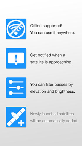
Yes. Newly launched satellites are added automatically when they have a realistic chance of becoming visible. Your device needs to be online to fetch the latest orbital data.
What do the numbers on the "MAP" mean?
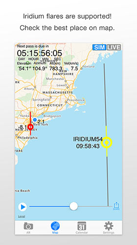
The number next to the blue dot (your current position) shows the satellite's brightness magnitude at that time. For Starlink trains, individual satellites are shown separately.
Why does a particular satellite never appear in the calendar?
Visible passes are not distributed evenly. Sometimes a satellite is visible frequently, and sometimes it does not appear for weeks.
Visibility also depends on your latitude. Satellites that fly near the equator, meaning satellites with small orbital inclinations, are hard to see or completely invisible from high-latitude areas.
For example, the ISS (orbital inclination 51.6 deg, altitude about 420 km) can produce passes of 15 deg or higher only up to about latitude 65. The Hubble Space Telescope (orbital inclination 28.47 deg, altitude about 540 km) is always invisible above about latitude 51. The Chinese Space Station also has a smaller orbital inclination than the ISS, so it may not be visible from high latitudes.
Starlink trains are temporary after launch, and their orbits differ from mission to mission, so whether you can see them depends strongly on the launch and your location.
Predictions that used to appear in the calendar have disappeared
Satellite predictions are calculated on the assumption that the satellite will keep its current orbit, but satellite orbits can change. The ISS in particular often performs reboost maneuvers to maintain its altitude. If a satellite's orbit changes, the app recalculates predictions using the updated orbit, and as a result the visible-pass entries in the calendar may change or disappear.
The heading in AR view seems misaligned
In AR view, the app uses your phone's magnetic sensor to determine direction, but magnetic sensors are affected not only by Earth's magnetic field but also by surrounding magnetic interference. This is especially common when you are in a vehicle or near metal-heavy buildings or bridges. In such cases, switch "Compass" to "Manual" in the Settings tab. You can then rotate the AR view by flicking it with your finger. If you already know the correct direction, or can align the view using a visible celestial object as a reference, manual adjustment may help you follow the satellite path more accurately.
How can I reduce battery usage?
The augmented-reality view consumes battery relatively quickly because it uses the camera and several sensors. You can save battery by using AR only when you need it. Other views, such as Map and Calendar, consume much less battery. If your battery is running low, we recommend turning on Low Power Mode in iOS Settings.
What OS and hardware does it require?
On iPhone and iPad, the app supports iOS 15.6 or later. On Android, it supports Android 6.0 (Marshmallow) or later. AR viewing requires camera access, and on iPhone and iPad it requires a usable back camera. Pass prediction depends on location access, although manual location selection is also supported. For the best AR experience, motion and orientation sensors are recommended for proper direction handling.
I found a bug or have a request
If you found a bug or have a request, please send it to us using the contact form.
Who built this app?
We're Toriningen Inc. in Tokyo, Japan. The team consists of two members, @hisashin and @MaripoGoda. The app was originally released in 2009 under the name "ToriSat".
We are always happy to hear your feedback via Twitter or email.

FAQ

SpaceStationARとは何ですか?
SpaceStationARは、AR (拡張現実)技術を活用した非常に直感的な衛星発見支援アプリです。 実際の風景に重ね合わせて、人工衛星がいつ、どのように見えるかを予報します。
どんな衛星をサポートしていますか?
肉眼での観望を目的としているため、ある程度明るく、見える可能性のある衛星や宇宙機をサポートしています。 代表的なものは、国際宇宙ステーション (ISS)、スターリンクトレイン、中国宇宙ステーション (CSS)、ハッブル宇宙望遠鏡です。 加えて、各種補給船や、Biomass、BlueWalker 3、だいち4号、SAOCOM、レスールスDK1、ENVISAT、SpaceMobileシリーズなど、肉眼で見える可能性のある各種衛星もサポートしています。 新しく打ち上がった衛星も、肉眼で見える可能性があれば自動で追加されます。
衛星はいつ見えますか?
宇宙ステーションは90分で地球を一周していますが、衛星に日光があたっていなかったり、昼間のように周囲が明るすぎると見ることはできません。
SpaceStationARは、衛星には日光があたり、かつ地表が暗いタイミング (夜明けか夕暮れ) を適切に計算して教えてくれます。
どこからでも見えますか? 双眼鏡は必要ですか?
ISS やスターリンクトレインのような明るい対象は、肉眼で見ることができるので、特別な機材は必要ありません。 特にISSは非常に明るいため、星を1つでも見つけられれば、ISSも見つけられる可能性が高いです。
衛星の見分け方は?
飛行機とほぼ同じ速度で飛んでいきますが、明確な違いとして衛星は点滅しません!また、仰角が高いほど明るくなります。
(参考) スペースシャトルとISSのランデブー
新しく打ち上がった衛星などは見られますか?
新しく軌道投入された衛星のうち、肉眼で見える可能性があるものは、SpaceStationARに自動で加わります。 なお、オフラインになっていると、新しい衛星の情報が取得できません。
「地図」の見方を教えてください
現在地の隣に表示されている数字は、その時刻における衛星の明るさの等級です。 スターリンクトレインでは、連なって見える個々の衛星をそれぞれ表示します。
特定の衛星のパスが全く表示されません
人工衛星が見えるタイミングには偏りがあり、頻繁に見える時期もあれば、なかなか見えない時期もあります。
また、観測地点の緯度によっては特定の衛星が全く見えないこともあります。
赤道付近の上空を周回する (軌道傾斜角が小さい) 衛星は、高緯度帯からは見えにくいか、まったく見えません。ISS (軌道傾斜角51.6°、高度約420km) の場合、仰角15°以上のパスが発生するのは北緯・南緯65°までの地域です。ハッブル宇宙望遠鏡 (軌道傾斜角28.47°、高度約540km) の場合は、北緯・南緯51°までの地域です。中国宇宙ステーションも ISS より軌道傾斜角が小さいため、高緯度帯からは見えないことがあります。
スターリンクトレインは打ち上げごとに軌道が異なり、軌道投入後の数日間だけ見やすい現象なので、見られる地域や時期が毎回異なります。
今までカレンダーに表示されていた予報が消えてしまいました
衛星の予報は、衛星が現在の軌道を維持することを想定して計算されますが、人工衛星の軌道は変化する場合があります。 特に、ISS は高度を維持するためにしばしばリブーストを行います。 衛星の軌道が変更された場合は、変更後の軌道に基づいて計算をやり直し、その結果として可視パスの内容に変更が生じることがあります。
AR画面で方位がずれているようです
AR画面では、スマートフォンに搭載されている磁気センサを使用して方位を把握していますが、磁気センサは地球の地磁気以外にも周囲の磁場の影響を受けます。 特に、乗り物に乗っているときや、金属の多い建物や橋があるときには、正しい方位を指さなくなる場合があります。 そのような場合、「設定」タブで「コンパス」を「マニュアル」にすることで、AR画面を指でフリックして回転させることができるようになります。 あらかじめ方位がわかっている場合や、目印となる天体が見えている場合は、フリックで方位を合わせることでより正確に衛星のパスを見ることができます。
バッテリーの減りが速いようです
AR画面はカメラや各種センサを使用するため、バッテリーを多く消費します。 地図やカレンダーなどの画面でのバッテリー消費は、一般のWebページ閲覧と同等程度です。 バッテリーを温存したい場合は、ARモードの使用を最小限にしてください。 (iOSの場合) OSの設定で「省電力モード」にすると、画質は落ちますが、バッテリーの消費が少し緩和されます。
オフラインでも使用できますか?
オフラインでも衛星の見え方を更新・表示することはできます。 ただし、衛星は時々軌道を変更することがあります。また、新しく打ち上げられた衛星が加わった場合もデータをネットワーク経由で更新する必要があります。 オフラインではこれらの情報が更新されず、古い情報に基づいた計算結果が表示されてしまう場合がありますので、なるべくオンラインでのご利用をおすすめします。
どのくらい正確ですか?
衛星を見つけるという本アプリの目的が損なわれることがないよう、基本的に方位は15度、時間は10秒以上ずれないように努めていますが、天頂を通過する時は誤差が大きくなりがちですのでご注意ください。
無料版とPRO版の違いは?
PRO版では、夜間観測に適した赤と黒の配色によるナイトモードと、衛星のパスを天球図で見る機能が利用できます。 無料版では広告が表示され、AR画面で衛星のパスを見られるのは通過の30分前からに制限されます。
対応OSや必要なハードウェアは?
iPhone / iPad では iOS 15.6 以降、Android では Android 6.0 (Marshmallow) 以降に対応しています。 AR表示にはカメラへのアクセスが必要で、iPhone / iPad では背面カメラが必要です。 衛星の方向や通過時刻の計算には位置情報が必要で、手動地点選択にも対応しています。 また、AR画面で正しい方向を表示するには、モーションセンサや方位センサを利用できる環境が推奨されます。
不具合のお問い合わせ・ご要望
不具合のご報告やご要望は、こちらのお問い合わせからお送りください。返信をご希望の場合は必ずメールアドレスをご記入ください。
誰が作っているの?
社員2名(@hisashin@MaripoGoda)の株式会社鳥人間が作成しております。2009年に "ToriSat" の名で発売されました。
このアプリのご感想をTwitterやメールで頂けると、大変嬉しいです。